From Chaos to Coordinates — How AI & Scan Data Make Every TAG Count
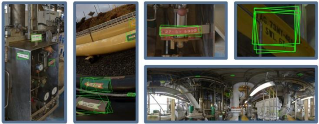
Why TAG plate georeferencing matters more than ever
Maintaining an industrial facility means relying on tens of thousands of identifiable assets — pipes, valves, instruments, safety equipment, structural elements, and more. Each one has a TAG number, and in theory, each TAG should be easy to find.
In reality, it isn’t.
Many operators struggle with:
- TAGs that are missing, painted over, or physically degraded
- Drawings and databases that are outdated
- Inconsistent photo documentation
- Time wasted in the field searching for equipment
- Difficulty using scans for inspection & maintenance planning
This is where AI‑supported TAG georeferencing changes everything.
How Capnor turns raw scans into georeferenced asset intelligence
Using a combination of 360° data, point clouds, and computer vision models, Capnor’s TAG recognition engine can automatically:
✅ Detect TAG plates in panoramas and scans
✅ Read and classify the TAG ID
✅ Position it precisely in 3D space
✅ Link it to system databases (SAP, Aveva, Hexagon, etc.)
✅ Visualize it directly inside Ayelix SDM
✅ Make it searchable from anywhere
This means operations, maintenance, inspection, brownfield engineering, and digital twin teams all work from the same factual, verified, and up‑to‑date source.
The value: faster work, safer work, smarter work
1. Field efficiency
Finding equipment becomes a 10‑second digital search instead of a 10‑minute physical hunt.
2. Better maintenance planning
Every asset has a precise position — enabling route planning for inspections.
3. Improved 3D models
Refineries, FPSOs, platforms, terminals, and plants can update P&IDs and engineering models faster.
4. A living digital twin
Georeferenced assets become part of a continuously updated digital representation of the facility.
AI-powered accuracy
Capnor’s recognition models are trained specifically on industrial environments. They can handle:
- Low-resolution TAGs
- Rusted/dirty plates
- Poor lighting
- Different languages & numbering systems
- Complex backgrounds
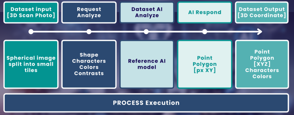
The system highlights confidence levels, so engineering teams can validate and approve automatically detected assets.
Aker BP, Equinor, and other operators benefit already
At several customer sites, thousands of TAGs are already identified, georeferenced, and available directly through Ayelix — enabling cross-department efficiency and reducing survey time dramatically.
Conclusion
TAG plate georeferencing transforms the way industrial facilities work with scan data and physical assets. It’s no longer just documentation —
✅ It becomes asset intelligence,
✅ accessible anywhere,
✅ instantly searchable,
✅ and always georeferenced.